In the text of white man's history, the Sacramento River has gone by
many names. Some point to the golden opportunities it brought
miners. Some trace the history of Spanish exploration -- it's said the
Spanish ``discovered'' the river on the Holy Day of the Sacrament in
1808.
The River of Destruction? It seems trappers were impressed by the upper river's springtime fury.
But the river is older than the white man's memory. And the
American Indians saw it first.
Sacramento Valley Wintu Indians call it Bohema-Mem (great-water), while the McCloud Wintus call it Nom-Tee-Mem (over-the-hill-water).
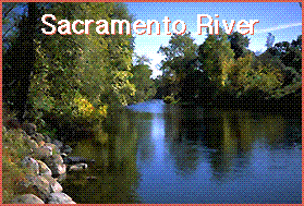
Behind the names lies the river's substance. The Sacramento is
California's largest river and meanders 384 miles from source to sea. Because of manmade manipulation, the Sacramento is actually two rivers; one is wild and relatively pristine, the other is lethargic and rather sullied.
Shasta Dam is the dividing line between the upper and lower river, but it's hardly the place where the river changes dramatically. The shift is gradual; the river transforms into a glorified ditch as it nears the city of Sacramento.
Indeed, the 54-mile stretch from Redding to Red Bluff has some of the most unspoiled riparian (riverside) forest in the state. Wild trout up to 7 pounds swim its waters; salmon school in its deep holes each year.
It's even better north of Shasta Dam, with white-water rafting and kayaking, swimming holes, waterfalls, challenging fly fishing pockets and unspoiled beauty.
The river gradually turns into an irrigation ditch for farms and
ranches, to a point where it no longer flows free.
At least 227 miles of river is encased in riprap levees, which control flooding but prevent the clean gravel salmon and trout need to spawn from entering the system. The Sacramento River has eight dams along its path that further limit salmon and steelhead
spawning.
But beyond the names and beyond the concrete intrusions, it is the people who add depth to the cold, jade-green waters.
Celebrities, simple folks
Mt. Shasta has a powerful allure for people, much as the moon
affects the tide. The 14,142-foot-elevation peak -- the flanks of
which are arguably the headwaters of the river -- attracts all kinds.
The river helps hold them.
``I had a dream I walked 14,000 steps and the sign on top said Mt. Shasta,'' said Linda White, a San Diego resident who sought refuge from the city last month at the Sacramento River headwaters in Mount Shasta City Park. ``When the mountain calls you, you come. You drink the water; you go with its flow.''
Andette Longsdale of Marin is a 19-year-old student who took the
summer off to travel the West. She left the Russian Wilderness in
Siskiyou County and was struck by the beauty of Mt. Shasta. She
camped for a few days next to the south fork of the Sacramento.
``I picked Mt. Shasta and this is the river that's here,'' she said, slowly strumming on her guitar. ``It helps me create my music.''
Frank Crosetti is 88 years old and can no longer navigate the river cobbles to fly fish. He's a bait fisherman now, quietly fishing from the banks with a night crawler and several years' knowledge of the river.
The ``Crow'' spends at least five weeks each summer away from his San Francisco Bay area home on the upper Sacramento River,
something he's done for years. People pass and wave as a courtesy among anglers, and most don't recognize who he is.
Crosetti also is one of the oldest living former players for the New York Yankees. He played shortstop in 1,682 games (good for 10th place all-time on the Yankees) in 17 seasons. He played with a guy named Ruth and a guy named DiMaggio. He coached the likes of Mantle, Maris and Larson in his 24 years as third-base coach.
``You know they've got a fly named after me ('The Cro') at Ted
Fay's,'' Crosetti said, referring to a Dunsmuir fly shop. ``I wanted them to change it to Crosetti, but they won't do it.''
While some are drawn to the area for its fishing, or the mountains, even a postcard can prove powerful enough to lure others.
Oscar Rodriguez and family, more than 18 in all, decided to come to Whiskeytown National Recreation Area last month for some rest and relaxation from the concrete jungles of the Bay Area. While on a drive up Interstate 5, Rodriguez stopped at a Dunsmuir gasoline station and saw the postcard rack.
There, amid pictures of Mt. Shasta and Castle Crags, were several of Mossbrae Falls in Dunsmuir.
``I saw that and knew we had to go,'' Rodriguez said. ``I asked for the directions, and the attendant told me right how to get here. It is a beautiful spot.''
Mossbrae Falls could quite possibly be the single most dramatic
feature of the Sacramento River. Cold-water springs burst forth from the canyon walls, where moss, ferns and other aquatic plants
prosper. The noise is deafening. The mist is chilling.
Dunsmuir residents like to think the falls belong to everyone.
However, the land where the falls emerge sits next to the Union
Pacific Railroad right-of-way and is owned by the St. Germain
Foundation, a religious group started by Guy W. Ballard in the 1930s.
The organization, with headquarters in Schaumberg, Ill., has more than 300 local groups throughout the world, as well as a reading room in Mount Shasta. People on the Dunsmuir campus like their privacy, but allow anyone to hike, picnic and swim at the viewing
area.
``It's always been an unstated, unspoken agreement, like with the UP right-of-way,'' said Will Newman, executive director of the Dunsmuir Chamber of Commerce. ``It's their courtesy and good will that makes it happen.''
A lot of people, Michael Hess included, come back to the river each
year, like the salmon. The Yucaipa resident bought into a cabin with
his father near the Scarlett Way bridge in Dunsmuir and makes a
habit of the river.
``I've been coming here for 35 years,'' he said as he walked toward
Dunsmuir from fly fishing to get his children for some inner-tubing.
``I want my kids to have the same opportunities I've had.''
Dan Baer is a returnee, too. The Anderson native left the north state
to teach biology in Santa Clara. He spent 31 years in the classroom
before buying some land and launching into retirement. Baer was
soaking his feet in the cool water while Boy Scout Troop 481 from
Anderson set up camp on what people jokingly call Danger Island
upstream from the Balls Ferry boat ramp. The group was into their
second day of a three-day canoeing and kayaking trip.
Baer grew up on the old Coleman National Fish Hatchery near
Anderson, where his father, Harry, was manager from 1942 to the
early 1970s. He worries that all the people moving to California will
not fathom the importance of the river.
``These guys who want to preserve the river need to gather up all
the old guys and get their anecdotes,'' he said. ``It's a wonderland,
if we keep it that way. It's the lifeblood of this place. It's the
circulatory system.''
Keswick Dam
Massive Shasta Dam may hold back the waters of Lake Shasta and is
the marker between the upper and lower rivers, but the smaller
Keswick Dam controls the flow of the Sacramento River on its trip
south.
Dam construction started in 1941 and was finished in 1950 to
protect lowland areas from uneven discharge from Shasta Dam,
which was finished in 1945.
Each day, water flows from the dam are checked and rechecked.
The output is measured in cubic feet per second (cfs). Typically at
this time of year, the flows from the dam are around 11,000 cfs.
The daily flows are set in Sacramento by the U.S. Bureau of
Reclamation and are sent by computer relay. The flows are based on
complicated models. Flow decisions are up to a committee of bureau
officials, state water authorities and weather forecasters. The water
quality in the Delta, the temperature of the river -- salmon and trout
need cool water to survive -- and agricultural needs all play a part.
Larry Ball and Gordon Huber make sure everything runs right in
Redding. Ball is the operations division chief for the bureau; Huber is
senior control operator in Keswick's windowless, computerized control
room. When everything goes right, these guys are far from the public
eye; when the river floods Tehama County walnut orchards or the
lowlands near Park Marina Drive in Redding, these are the guys in the
hot seat.
``Right now, things are basically on auto-pilot; there's a certain
amount of water that's needed to be let out,'' Ball said. ``But when
there's a flood control concern, there is more public and media
attention. For flood control issues, we are concerned about property
and public safety.''
|
The Sacramento has always been a highway of many names.
Lieut. Robert Emmons charted the Upper Sacramento as "Destruction River" perhaps (says Julian Dana) because he confused it with the McCloud, from which Alexander Roderick McLeod had carried a story of hard luck back to Vancouver. Padre Narciso Durán supposedly gave it the name it bears today. Lt. Joaquin Moraga called it the Jesus Maria. The trappers named it the Spanish River. Some called it the Bonaventura and some just the River of the North.
|


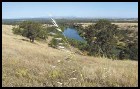
Recreation to commerce
Past the Red Bluff Diversion Dam, the river begins to change, but
those changes are subtle. Anglers still fish the holes and riffle for
salmon and trout, but there riparian forest is interrupted by ranch
land. Cattle graze near the water's edge.
Shasta County Supervisor Glen Hawes is a living history book of river
information. He grew up on Hawes Ranch, which his grandfather
William homesteaded in the early 1860s. The original ranch was 3,000
acres, roughly across from the Anderson River Park down to the
mouth of Cow Creek. The property was split among three brothers in
the 1950s, and now goes from the Deschutes Road bridge to the
mouth of Cow Creek.
``It's great for irrigation, it's beautiful, people used it to fish, it's a
nice place to recreate,'' Hawes said recently. ``But it's kind of a wild
river, really. There have been a few times that it's flooded my
orchards, and that's been after the (Shasta) dam was put in.''
9.12.99